Agreed. Apparently, there are unpaved roads that could take you from Beaver Dam east toward AZ-389. Fifty miles worth, easily. Don't know if you'd taken that kind of an off-road journey back when you lived out there.
Put it in the "can't get there from here - easily!" category.
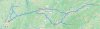
Playing around for 20 minutes with what
@PilotJO started with, I came up with this slightly-more-than-2000-mile jaunt around
most of Arizona. Probably the closest thing to a lap around the state that there will be for some time to come.
https://tinyurl.com/ycu679pb
Certain places used were to ensure Google wouldn't try and take the easy way to a subsequent location.
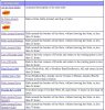
Fort Mohave, AZ
near Willow Beach, AZ
Flagstaff, AZ
Fredonia, AZ
Marble Canyon, AZ (map shaping)
Teec Nos Pos, AZ
Ganado, AZ (map shaping)
Alpine, AZ
Hannagan Meadow, AZ (map shaping)
Duncan, AZ
Willcox, AZ
Douglas, AZ
Sonoita, AZ
Nogales, AZ
QuikTrip, 3345 W Valencia Rd, Tucson, AZ 85746 (map shaping - this location keeps you to a minimum of traffic congestion in the southern end of Tucson)
Ajo, AZ
San Luis, AZ
Parker, AZ
Lake Havasu City, AZ
Fort Mohave, AZ
Google claims 34 hours, around 2006 miles. Various routing tweaks might lower that mileage.
EDIT:Even with some shaping, still didn't come out right, as the routing does go onto I-40 near Needles, California. Ugh.

")