
In a rally it can be helpful at the beginning to first look at what is the furthest point I can reach. To do this, I can calculate the maximum kilometres with the help of various Excel spreadsheets (e.g. this one on the German 12hours website). Let's say you reach 4400km. But you also have to go back - so halve it, then it's still 2200km.
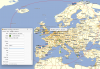
But how can I display this in BasCamp? It's very simple - open a bonus point and enter this value in the Proximity field. When you leave the field, a circle with the 2200km diameter appears immediately.
But since no one drives as the crow flies - we have to adjust the value. This is where it gets tricky - I make up 3 routes in three directions. To Scandinavia / Greece, that would mean 3,000km each, but to Spain only 2,400km.
That means - if I go to Spain, I'll stay on the straight line (but I still have to subtract 20% (so radius around 1800km, in the other two directions it's more like 40% as we seem to be taking a lot of bends.... So I use a radius of e.g. 1500km.
So it will look like this. Two lines around a point does not work, so just duplicate the point (with a different name)
For me, the inner red circle would be my new destination - if I were to travel to Greece. Anything outside is fraught with the risk of getting a lot of stress over time....
But how can I display this in BasCamp? It's very simple - open a bonus point and enter this value in the Proximity field. When you leave the field, a circle with the 2200km diameter appears immediately.
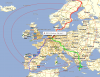
But since no one drives as the crow flies - we have to adjust the value. This is where it gets tricky - I make up 3 routes in three directions. To Scandinavia / Greece, that would mean 3,000km each, but to Spain only 2,400km.
That means - if I go to Spain, I'll stay on the straight line (but I still have to subtract 20% (so radius around 1800km, in the other two directions it's more like 40% as we seem to be taking a lot of bends.... So I use a radius of e.g. 1500km.
So it will look like this. Two lines around a point does not work, so just duplicate the point (with a different name)
For me, the inner red circle would be my new destination - if I were to travel to Greece. Anything outside is fraught with the risk of getting a lot of stress over time....