I have ridden with a TomTom Rider for several years and it served me well but I wanted to move to Garmin as the rally planning tools seem to be better for it.
So early this year I picked up a new-in-the-box Zumo 660 and have been on several rides. One thing that I can't seem to get right is the adjustment for routing on the gps unit. It seems like it wants to route me via the shortest route despite the fact that it is set to go the fastest route.
For instance, I was leaving a gas stop on the west side of Montgomery, AL planning to head north towards Chattanooga, TN. The gps wanted to route me on some backroads which would have been the shortest route by about 5 miles over the obviously fastest route of running up the Interstate towards Birmingham.
If this is normal then I'm frankly very disappointed in the Garmin. The routing preference has been checked and confirmed several times. Any thoughts?
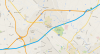
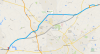
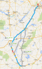
")