PilotJO: The mention of "being submitted" referred to proposing a new In-State "Lap Of" ride or In-State "Ride Around" ride to be added to the list of rides attached below.

Lap Around Arizona
- Thread starter PilotJO
- Start date
Hey all. I'm interested in the Lap of Arizona as well. Although not right now with snow already in the White Mountain area. I am thinking of doing a SS1000 or BB1500 to hit at least one point in each of the counties in a state type of ride. Has anyone mapped out hitting at least one point in each of the 15 counties of Az? Working on one myself right now but hard to find a route mapper that includes county borders on the map.
I guess it was a little easier to do than I thought. Thoughts on if this is a a certifiable ride route?
https://www.google.com/maps/dir/Tem...d392cb41f!2m2!1d-111.9400054!2d33.4255104!3e0
https://www.google.com/maps/dir/Tem...d392cb41f!2m2!1d-111.9400054!2d33.4255104!3e0
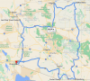
I just happened to come across this thread tonight. Howard and I have been in casual conversation for a few months about the Ride Around Arizona and he knows that you really can't hit all four corners and get a DBR at those locations. We're still in discussion but this is the most recent map that I sent him. I don't plan to ride this until after the snow melts in the higher elevations, and even then it will just be a preliminary shakedown ride to ensure that fuel can be obtained, receipts can be obtained, and to see what the anticipated travel time will be. If someone else wants to jump in line ahead of me I certainly have no issues with that; just make sure you run everything by Howard before you start riding.
I guess it was a little easier to do than I thought. Thoughts on if this is a a certifiable ride route?
https://www.google.com/maps/dir/Tem...d392cb41f!2m2!1d-111.9400054!2d33.4255104!3e0
https://www.google.com/maps/dir/Tem...d392cb41f!2m2!1d-111.9400054!2d33.4255104!3e0
Has anyone tried applying the "Lap Of" rules in the "Lap of Tennessee" rules page in creating a "Lap Of" route for Arizona? Notice, you do not have to finish in the same city where you started. This could possibly also apply to Montana, Nevada, New Mexico, Oregon, Utah, and Wyoming.
")
The four 'corner' locations to easily access fuel 24 hours a day are San Luis, Douglas, Red Mesa and MM27, which is closest to White Hills. Google rough map for discussion - note that Hannagan Meadow and Safford are waypoints, otherwise, Google WILL route you into New Mexico.
https://goo.gl/maps/5u4xUe7DQUSbgEBA7
Going back to the starting point gives a 26 hour, 1582 mile ride. The delta between what @Brian Thorn posted above and this really doesn't get you significantly closer to making a full 'ride around' of the state.
https://goo.gl/maps/XaUDRB3jwMiST5JDA
The eastern edge of that route is 500 miles, of which 90 miles or so between Clifton and Alpine is the fun & twisty part of that highway.
Back to Brian's map...from Page, you can back-track and get to either Fredonia or all the way to Colorado City. There looks to be a single fuel stop in Colorado City, and that's 142 miles one-way from Page. There's always the Jacob Lake stop for fuel, and no fuel @ Bitter Springs, which you pass thru to get back onto US-89, which is where @Russ Black mileage comes from, I suspect.
So, 2000 miles divided by ~43MPH is 46.5 riding hours. Rough in another 8.5 hours for non-moving activities (make the math easy...) and that's 55 hours. The simple fact of back-tracking to account as much as possible for that north-western edge makes that ~280 miles something of a "Why bother?" part of the ride.
There is no reliable gas in Colorado City. Most go across the border to the Border Store for gas, putting it beyond the border of AZ. There is gas at the Arizona Last Stop, a tad farther North than the "Last Stop Travel Center" on 93. Not sure if it's 24 hour pumps or not.
FIFY - LINK with gas stations instead of cities, all of which have addresses in the required cities. Is it really a "Lap of" if you don't close the loop, but still hit the corners? If you closed the loop, you could stop at Kingman if you started in White Hills. Just a thought. LINK trims it to 1528 miles.
FIFY - LINK with gas stations instead of cities, all of which have addresses in the required cities. Is it really a "Lap of" if you don't close the loop, but still hit the corners? If you closed the loop, you could stop at Kingman if you started in White Hills. Just a thought. LINK trims it to 1528 miles.
Gas @ 36.972243, -112.974215 per Google Street View from April in Colorado City.
The "Lap of ..." rides are drawing the approximate shape of the state as a part of the ride. Arizona doesn't qualify for the reasons discussed earlier.
So, it's simply how much of Arizona is sufficient for a "Ride Around..." ride. Choosing which NW corner location is left to the first person that physically does the ride and submits it for approval.
Doing a significant amount of backtracking to get to locations along the southern border...looks like this: https://goo.gl/maps/nkUp6aFmxZA765YD9
Lukeville & Sasabe are NOT 24/7 fuel locations that I know of; the border crossings are closed during late night/early morning hours.
Semantics...