Ride to Eat Nr 2 Center of France Bruere-Allichamps April 27, 2019
- Thread starter michiel kerkhof
- Start date
Probably the wrong Champvalliers - there are several. It is the Champvallier north of 03190 Nassigny. Unfortunately, I don't have the co-ordinates. Long time ago I have been there. Very remote - not even on street view or similar.
Please, have a look on https://www.kunstgeografie.nl/centres/centre.mich.htm
Champvallier north of 03190 Nassigny is the most recent accepted estimation of the geographical center of France (corresponds to your picture).
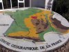
The monument at the crossing of the village of Bruère-Allichamps is a historical estimation of the geographical center of France but the most visited one (corresponds to the picture from JON12A).
Cheers,
Ralf
Please, have a look on https://www.kunstgeografie.nl/centres/centre.mich.htm
Champvallier north of 03190 Nassigny is the most recent accepted estimation of the geographical center of France (corresponds to your picture).
The monument at the crossing of the village of Bruère-Allichamps is a historical estimation of the geographical center of France but the most visited one (corresponds to the picture from JON12A).
Cheers,
Ralf
Last edited:
Have a look at this. I agree with Ralf that the sign is near Nassigny I still think it is on the road to Champvallier which is a tiny hamlet to the north west.
https://www.google.co.uk/amp/s/www....ce-en-tole-faconnee-avec-passion_1647452.html
https://www.google.co.uk/amp/s/www....ce-en-tole-faconnee-avec-passion_1647452.html

I think it's on one of the roads with no streetview coverage near Nassigny
https://www.leberry.fr/nassigny/vie...le-faconnee-avec-passion_1647452.html#refresh
https://www.leberry.fr/nassigny/vie...le-faconnee-avec-passion_1647452.html#refresh
Lets going with Michiel! But...https://www.leberry.fr/saint-amand-...identifiees-centres-de-la-france_1646430.html
Lets going with Michiel! But...https://www.leberry.fr/saint-amand-...identifiees-centres-de-la-france_1646430.html
https://www.kunstgeografie.nl/centres/centre.champvillier.htm
on this link I have the place where it is supposed to eb North ofChampvillier but I have no clue with streetview.....cant get that to work with me......
on this link I have the place where it is supposed to eb North ofChampvillier but I have no clue with streetview.....cant get that to work with me......
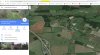
https://www.google.pt/maps/place/46...0x0:0x0!7e2!8m2!3d46.5118074!4d2.576527?hl=nl
Some info tells me it shud be a little north of Champvilliers and this is a spot which could be it but unsure and cant get streetview to check.....so I'll go there in febr to make sure the coordinates are OK ...this spot is N46 30.42.5 and E 2 34 35.5 some strange method of coord that google gives me....why is there not 1 system to do coordinates but several which I cannot translate into some normal that BC can read!!!
Some info tells me it shud be a little north of Champvilliers and this is a spot which could be it but unsure and cant get streetview to check.....so I'll go there in febr to make sure the coordinates are OK ...this spot is N46 30.42.5 and E 2 34 35.5 some strange method of coord that google gives me....why is there not 1 system to do coordinates but several which I cannot translate into some normal that BC can read!!!