48/10 Preliminary Planning

CB650F

Premier Member
#1
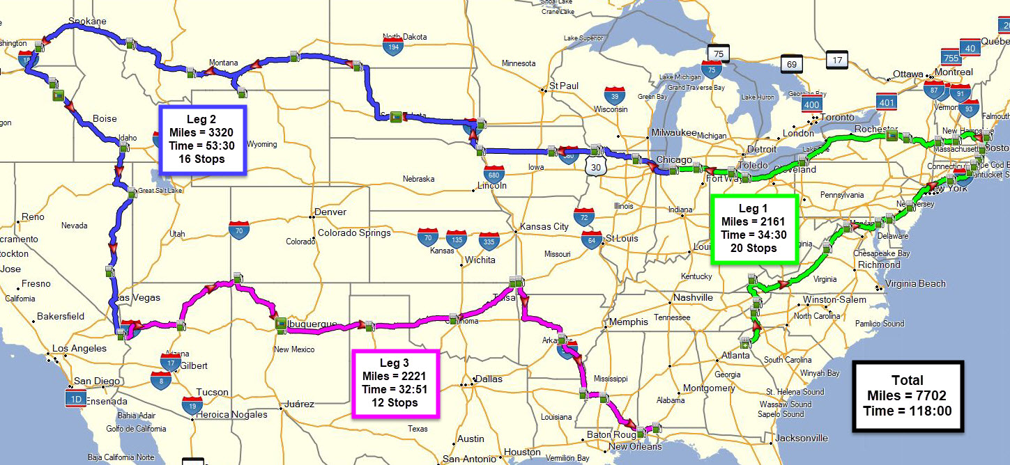
I've been doing a bit of research lately into planning a route for the 48/10 ride. I've looked at a few rides from people who posted their routes here on the forum, and a few more from Google searches. I think I've found a route that hits all 48 states in 7 days averaging 15 hours and 958 miles a day. In mid-June, that's basically riding all day and sleeping a full night every night. And you'd have 3 days for R&R at the end. Naturally, one of those days is going to be used for whatever weird, unexpected thing comes up, or just a day of R&R in the middle of the ride, or two half days, etc. Or, what is more likely, is two long days at the start to knock out 2,000 to 2,500 miles, then 700 to 800 mile days for the remainder of the and a really easy final day, or just a day of R&R depending on the specifics.

There is a big downside to this route. It starts and ends on different sides of the country. For me, that's just another opportunity to take my time on the way back and collect some National Park stamps, or Pressed Pennies, or do a Sunrise to Sunset ride, or make another push and reverse the route for a back to back 48/10. Yea, I know, back to back 48/10 is a difficult ride to say the least, but this route is 1500 miles shorter than most circular routes. 1500 miles amounts to an extra day or two per leg, which can be up to a 4 day break in the middle of the run. That's a lot of extra R&R that can be spread out throughout the ride specifically to avoid burnout. Ride 3 days, rest one, rinse, repeat.

Clearly, this ride isn't going to happen until well after everything opens up, but I'd still like to get some feedback. This is the first part of the route, and this is the second part. Google Maps didn't have enough waypoints for me to easily fit it on 1 map, so I made two. I also just picked a random gas station or food joint in the cities I used as waypoints, so those are just route markers to make sure I hit every state. Okay, critique my plan! I'm quite certain I've managed to forget something, or overlooked an obvious issue that will be clear to those that have done this before. What did I forget? Am I planning to go through a city that I'd be better off going around for safety reasons? Did I somehow miss a state? Help fix my plan.

Edit: For some strange reason, the links are showing up as email links. I don't know why, but if you right click them and then click "Copy email address" and paste that into the address bar, they work. Not sure what I messed up there. Links are usually easy.
Edit again: Tried to close my email and fix the links. Hopefully it works this time.
 
Last edited:

kwthom

=o&o>
Premier Member
IBA Member
#2
I'd agonized over your first part of the problem: Efficient overall route -or- route that has me (reasonably) close to home when it was done. I chose the latter option, and darn glad I did.

1. Your route in the Chicago region...you're not going to enjoy it - unless your plan is to do that in the middle of the night.

2. You may want to seriously study fuel/receipt opportunities in your short routing in the state of New York.

Consider a variation of this:

TrackOverviewMap_B.png

Consider adjustment the WA - NM leg to fit your start location (or ending, depending on if you chose to run this CW or CCW. You could adjust AZ/NM to sail across I-40 to OK (from Needles, CA), then drop into the bulk of the common routing. Fuel locations known; all routing uses EZ-Pass tolling to make that a non-issue.

If running CCW, your last state would be ID, and you'd be much closer to home.
 

CB650F

Premier Member
#3
1. Yea I agree with you there. Chicago won't be any fun. I highly suspect Philly and NYC will be in that category too. Do you think it's worth heading south on I-39 in Rockford to I-80 and then east through Joliet instead of staying on I-90 through Chicago? Actually, your spotwalla track is linked in your ride report thread isn't it? I do remember flipping through that thread.

2. My route through Delaware is really short too. Total length of about 15 to 20 miles. I ass-u-me-d going through NYC would provide easy access to fuel though. No?

Oh, and I don't live in the Northwest. I'm a full time RVer. I'm currently in Arkansas. My domicile is in South Dakota and I'll be heading back there for a little while when I leave Arkansas. Over the summer, there is rarely any work in my field so I kinda have all summer to mess around with. Starting and ending locations don't really matter much to me. That's kinda how I ended up with that route. I tried a route very similar to yours, but moving around the start and end to give the biggest gap between them. Then I realized, biggest gap would be east coast to west coast. Turns out, that cuts about 1500 miles off the trip.

I do need to find a good place to get an EZ-Pass for the northeast. I typically avoid toll roads, but they save so much time up there that you practically have to use them.
 

kwthom

=o&o>
Premier Member
IBA Member
#4
Philly? My PA stop was in the 'panhandle' of the state along I-90 - like 28 miles worth. My stops were intentionally routes to avoid (where possible) any need to stop in major, congested areas. Passing from CT thru NY, around eastern PA and into NJ sure saved me a bit of time.

I came from the NJ Turnpike south into DE, so yeah, only about 24 miles worth of I-95 in the state. That whole NE region was a big reason why I used the stop locations that many others have used in the past. Nearly every one of them have been laid out so they are along your thoroughfare you're using to go from one state to the next.

EZ-Pass? Get the
NC Quick Pass as I believe it is still the most interoperable choice for the more common routes you'll be using for a route similar to the one you're considering. I suppose a person *could* attempt to do much of a ride like this & avoid the toll roads. The additional $90 or so (tolls, plus acquiring the toll tag) was worth the price to pay. Especially the first few times you sail thru the tolling area at 45 MPH.

I did I-90, I-355, I-80, then onto I80/I90, just east of Gary, IN. - avoiding much (but not all) of the rush-hour traffic on a Friday afternoon.

I had a nearly 900 mile gap between my start location and my end location. Home is between 'em.
 

Stephen!

Flivver Flyer
Premier Member
IBA Member
IBR Finisher
#5
Edit: For some strange reason, the links are showing up as email links. I don't know why, but if you right click them and then click "Copy email address" and paste that into the address bar, they work. Not sure what I messed up there. Links are usually easy.
It appears you have copied a link from your email and pasted it here... I do not think anyone can do anything with it without being logged into your email account...

20200511_135159.jpg
 

Greg Rice

Premier Member
IBR Finisher
#6
I have a 48 state ride in the planning for sometime in the future. I decided to create a route that starts and ends close to home as time is always short for me and getting more than a week off is difficult. Here is my current route. It is 7,700 miles and I always plan aggressive times. ;)

My route is based on past 48 state rides with some changes that fit better for me. Of course when the time comes to do the ride it could change.

 
Last edited:

CB650F

Premier Member
#8
It appears you have copied a link from your email and pasted it here... I do not think anyone can do anything with it without being logged into your email account...

View attachment 5075
Yea, that is what it looks like, but I just opened the link in another tab in my browser, and closed everything else running, and tried to edit the link to the proper web address. Sadly, once again, the link is mailto:... instead of just https://www.google.com/maps/dir/... It's a simply copy and paste, and it will paste correctly from the clipboard, but somehow the link changes it once I save it. I don't know what the heck is going on. Can a mod fix it maybe? Should just have to remove the "mailto:" tag. Ugh, now I feel old.
 

Greg Rice

Premier Member
IBR Finisher
#9
@Greg Rice This is the route similar to what I was going to follow. Was going to ask @kwthom for his notes and places he stayed at and recreate something similar. No point in reinventing the wheel.
If you want send me an email to [email protected] and I will send you my GPX file of my route. It has all 48 gas station stops my planned hotel stops.
 
#19
I'd agonized over your first part of the problem: Efficient overall route -or- route that has me (reasonably) close to home when it was done. I chose the latter option, and darn glad I did.

1. Your route in the Chicago region...you're not going to enjoy it - unless your plan is to do that in the middle of the night.

2. You may want to seriously study fuel/receipt opportunities in your short routing in the state of New York.

Consider a variation of this:

View attachment 5073

Consider adjustment the WA - NM leg to fit your start location (or ending, depending on if you chose to run this CW or CCW. You could adjust AZ/NM to sail across I-40 to OK (from Needles, CA), then drop into the bulk of the common routing. Fuel locations known; all routing uses EZ-Pass tolling to make that a non-issue.

If running CCW, your last state would be ID, and you'd be much closer to home.
Do you have a copy of this route in a GPX format, a link to the route, or even address or gps coordinates for the stops?
 

EricV

Premier Member
IBR Finisher
#20
@18FLHP - You just bumped a 2 year old thread. You'd be better off PMing the individual you want info from at this point. @kwthom is a frequent visitor here, but direct contact is better on old threads.