Brit Butt Tour 2022
- Thread starter wully
- Start date
Maybe a better idea to post this in the 2022 thread.
Help, I'm interested in entering the Brit Butt Tour but how would I translate the cordinates from the rally Book into a format that either my TomTom Rider or ITNConverter will recognise?
Lets use N59° 05.581' W3° 10.887 as an example because i'm probably being a **** here.
Help, I'm interested in entering the Brit Butt Tour but how would I translate the cordinates from the rally Book into a format that either my TomTom Rider or ITNConverter will recognise?
Lets use N59° 05.581' W3° 10.887 as an example because i'm probably being a **** here.
")
Now resolved. I hadn't realised Wully would send me a Garmin gpx file which I can open with ITN Converter
From there I'm two clicks away from saving it directly to my TomTom Rider or TomTom My Drive Connect, either as a Route or a POI (ov2) file.
Happy days
From there I'm two clicks away from saving it directly to my TomTom Rider or TomTom My Drive Connect, either as a Route or a POI (ov2) file.
Happy days

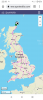
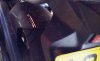
I've now made my start with a 400 mile sortie around Kent, Sussex and Surrey for day one of my first ever IBA UK Tour/Rally. It didn’t go as smoothly as I’d like but hey ho happy days nonetheless.
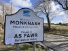
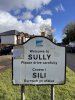
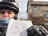
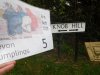
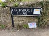
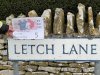
On my first attempt to capture a bonus location, Thong (41), and I forget to include my rally flag, fortunately I realised my school boy error before heading off. At my second location Gravelly Bottom Road (55) the sign wasn’t as expected, two runs up and down the road and I failed to identify the correct sign, so I took a photo of the sign that was there. After returning home a check on Google Maps revealed the sign had been replaced.
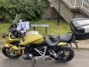
Disaster struck on the A259 heading towards Rye. I was startled by what sounded like a short burst of rapid gun fire which turned out to be a puncture to the rear tyre. The sound I heard was whatever object that had pierced the tyre had also gouged an 80x10mm slit in the rear hugger! Puncture repaired and a progressive ride got me to the ‘daylight only’ Juggs Close (24) just in time. My last three locations were visited after sunset and included bagging the correct signs as depicted in the rally book for Cockmannings Road and Nork Rise.
Subject to Wully’s approval I managed nine locations.
On my first attempt to capture a bonus location, Thong (41), and I forget to include my rally flag, fortunately I realised my school boy error before heading off. At my second location Gravelly Bottom Road (55) the sign wasn’t as expected, two runs up and down the road and I failed to identify the correct sign, so I took a photo of the sign that was there. After returning home a check on Google Maps revealed the sign had been replaced.
Disaster struck on the A259 heading towards Rye. I was startled by what sounded like a short burst of rapid gun fire which turned out to be a puncture to the rear tyre. The sound I heard was whatever object that had pierced the tyre had also gouged an 80x10mm slit in the rear hugger! Puncture repaired and a progressive ride got me to the ‘daylight only’ Juggs Close (24) just in time. My last three locations were visited after sunset and included bagging the correct signs as depicted in the rally book for Cockmannings Road and Nork Rise.
Subject to Wully’s approval I managed nine locations.