Cali HYW 36

#1
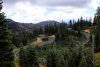
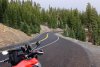
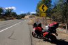
Hello folks, hope everyone is well and preparing there bikes for the season start. We are planning another epic ride from beautiful BC to even more beautiful California. We have bin dreaming about HYW 36 for a very long time and this Summer we will do it. I would love to know more from ppl. who have done the dream 140 miles of a pure twistiness. This time we will be riding hyper naked bikes and are interested for any helpful input about best days, months, speed traps, Hotels, foods, trusted bike shops for European naked models, road condition's, interesting check points worth to stay and visit it, also are radars legal in Cali ? etc..... etc...
Cheers
 

keithu

Premier Member
IBA Member
IBR Finisher
#2
CA-36 is just one of many outstanding roads in NorCal. I rode it most recently in October of 2022. The most famous section is of course the stretch from Red Bluff to US-101, but if possible I recommend you also ride the portions east of I-5. A nice route would be CA-89 from Mount Shasta down through Lassen Volcanic NP, and then take CA-36 all the way to US-101. The park is stunningly beautiful, and you'll enjoy roads like this:

2022_1022_12265200s.jpg

2022_1022_12084600s.jpg

West of Red Bluff is the famous "Winding road next 130 miles" section. You'll see everything from oak savannah, coast range canyons, and giant redwoods. The western stretch is curvier, yes, but IMO the ride through Lassen and the eastern portion of CA-36 is more scenic. Road conditions are overall pretty good. Weather should be perfectly safe any time May-September. It might also be rideable in March-November, but you should monitor local weather in the shoulder seasons. I'm not much of a "stopper" so I'm afraid I can't tell you much about local stops.

2022_1022_13571100s.jpg

Yes, radar detectors are legal in California, as well as Oregon and Washington. If you're coming down I-5, be careful through Salem, OR. The local sheriff has been using laser on I-5 through Salem pretty heavily lately. They like to set up near the speed limit transitions between 60mph and 65mph.

All the other roads around there are great too: CA-96, CA-3, CA-299, etc. CA-96 from Willow Creek to I-5 near Yreka is perhaps my favorite ride of all time. It's 150 miles of pure bliss connecting Nowhere to Noplace. I have ridden CA-96 on a beautiful summer Saturday and seen fewer than 10 cars over the entire 150 miles.
 
Last edited:

keithu

Premier Member
IBA Member
IBR Finisher
#3
One other thing: I-5 sucks. When transiting Oregon I strongly suggest US-97 instead. It has the same speed limits most of the way but far less traffic and much, much nicer scenery. I-5 can be a parking lot between Portland and Eugene any day or time of the week.
 

IBA ZX-9R

Well-Known Member
#4
CA-36 accounts for 140 miles of my traditional annual SS1K. Highly recommended!

Start time: Monday 06/13/22 at 12:49 AM
NW Reno, NV - Petaluma, CA - Bodega Bay, CA (CA-1, Pacific Coast Highway)
Bodega Bay, CA - Gualala, CA - Leggett, CA (All CA-1)
Leggett, CA - Eureka, CA - Brookings, OR
Brookings, OR, - Eureka, CA, - Fortuna, CA
Fortuna, CA - Red Bluff, CA - Corning, CA (CA-36)
Corning, CA - Vina, CA - Chico, CA
Chico, CA - Orovilla, CA - Comptonville, CA (CA-49)
Comptonvilla, CA - Sierraville, CA - Truckee, CA (CA-49 - CA-89)
Truckee, CA - Sparks, NV, to SE Reno, NV
End time: Monday 06/13/22 at 10:17 PM

Iconic Highways in route
CA-1 Pacific Coast Highway (beginning of video at Bodega Bay, CA (CA-1) heading north to Leggett, CA, @47:15
CA-36 Volcanic Legacy Scenic Byway @2:08:10 - 2:41:48
CA-49 Golden Chain Highway, via Oroville, CA 2:49:37 - 3:23:50. Various backroads to CA-49 to Truckee, CA, via CA-89.
:)
 

IBA ZX-9R

Well-Known Member
#6
Sure, but where would I put them in a Ninja sportbike? I don't need the extra lighting to see at night. Low beam dual headlights are more than enough. Action-cam video capture, costs, and editing time, make the process a compromise. I could set the camera for night mode, but then I'd need to adjust it during the ride for the light conditions at dawn, then once again for full daylight. Then reverse the procedure as night falls. Or I could have turned on my highbeams to raise the lighting angle and brightness, but I've had bad luck with doing so in grass covered forested areas near dawn/dusk. I get too many animals who think it's now safe to jump into the well lit road.

This is my own personal recording, to relive the adventure and use as workout training video for future IBA rides. It's a backburner frill item, while carrying out the very real task of accomplishing a twisty course SS1K on a sportibke. As it was, with maximum memory card sizes and taking 1080P audio/video this time, the whole SD card swapping out/in was a choreographed pre-planned event in and of itself. I've received a number of E-mail requests from other riders asking me how I managed to record 20+ hours of nonstop action-cam footage. To which I reply the details. The few that have replied back are generally aghast, which is probably why there's not a whole lot of privateer content like this.

True, I wished some of the video turned out better, but it's not bad either. If I placed the camera in front of the windscreen, for instance, the color resolution would have been much better, but then the camera would have collected ocean marine layer moisture and bugs and could have been worse; needing constant cleaning.

But I plan to experiment before this year's ride and see if v4.0 will be better. :) Version one and version two, GoPro Hero 3 recordings, would have definitely been on many people's thumbsdown lists, despite the effort put into stringing together 67,000 still captures into soundless video form.
 
#7
CA-36 is just one of many outstanding roads in NorCal. I rode it most recently in October of 2022. The most famous section is of course the stretch from Red Bluff to US-101, but if possible I recommend you also ride the portions east of I-5. A nice route would be CA-89 from Mount Shasta down through Lassen Volcanic NP, and then take CA-36 all the way to US-101. The park is stunningly beautiful, and you'll enjoy roads like this:

View attachment 9791

View attachment 9792

West of Red Bluff is the famous "Winding road next 130 miles" section. You'll see everything from oak savannah, coast range canyons, and giant redwoods. The western stretch is curvier, yes, but IMO the ride through Lassen and the eastern portion of CA-36 is more scenic. Road conditions are overall pretty good. Weather should be perfectly safe any time May-September. It might also be rideable in March-November, but you should monitor local weather in the shoulder seasons. I'm not much of a "stopper" so I'm afraid I can't tell you much about local stops.

View attachment 9793

Yes, radar detectors are legal in California, as well as Oregon and Washington. If you're coming down I-5, be careful through Salem, OR. The local sheriff has been using laser on I-5 through Salem pretty heavily lately. They like to set up near the speed limit transitions between 60mph and 65mph.

All the other roads around there are great too: CA-96, CA-3, CA-299, etc. CA-96 from Willow Creek to I-5 near Yreka is perhaps my favorite ride of all time. It's 150 miles of pure bliss connecting Nowhere to Noplace. I have ridden CA-96 on a beautiful summer Saturday and seen fewer than 10 cars over the entire 150 miles.
OMG, that is amazing. Thank you for all the info, I think we will need definiftive to stay a vbit longer as planned :)
 
#8
CA-36 accounts for 140 miles of my traditional annual SS1K. Highly recommended!

Start time: Monday 06/13/22 at 12:49 AM
NW Reno, NV - Petaluma, CA - Bodega Bay, CA (CA-1, Pacific Coast Highway)
Bodega Bay, CA - Gualala, CA - Leggett, CA (All CA-1)
Leggett, CA - Eureka, CA - Brookings, OR
Brookings, OR, - Eureka, CA, - Fortuna, CA
Fortuna, CA - Red Bluff, CA - Corning, CA (CA-36)
Corning, CA - Vina, CA - Chico, CA
Chico, CA - Orovilla, CA - Comptonville, CA (CA-49)
Comptonvilla, CA - Sierraville, CA - Truckee, CA (CA-49 - CA-89)
Truckee, CA - Sparks, NV, to SE Reno, NV
End time: Monday 06/13/22 at 10:17 PM

Iconic Highways in route
CA-1 Pacific Coast Highway (beginning of video at Bodega Bay, CA (CA-1) heading north to Leggett, CA, @47:15
CA-36 Volcanic Legacy Scenic Byway @2:08:10 - 2:41:48
CA-49 Golden Chain Highway, via Oroville, CA 2:49:37 - 3:23:50. Various backroads to CA-49 to Truckee, CA, via CA-89.
:)
Thank you, grate vidoe btw. all respect for doing SS1 on a Sport Bike
 

Stephen!

Flivver Flyer
Premier Member
IBA Member
IBR Finisher
#9
Or I could have turned on my highbeams to raise the lighting angle and brightness, but I've had bad luck with doing so in grass covered forested areas near dawn/dusk. I get too many animals who think it's now safe to jump into the well lit road.
Translation: If I do not see them, they are not there. :D