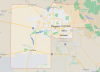
I've been thinking about doing an in County SS1K ride. I live in Maricopa and its overall size and vast freeway system would make it fairly reasonable to accomplish. I use Spotwalla for my trips and tag each fuel stop with a picture in my trip log. What else should I do, or add as documentation that I completed my mileage while staying within county lines? I think it'd be a fun ride to do once.
Greetings, Mike …
The short answer: Yes, your pictured route is entirely within Maricopa County.
More details:
We don’t have a specific description for an
In-County ride, but such a ride is a reasonable extension of the In-State & In-City rides; most of the guidelines and requirements for those would apply.
In particular, for such rides …
- Pre-approval by IBA of the proposed ride is required, including the route (a GM link) as well as the locations of the
planned fuel stops which will be available during the time of the proposed ride (a note)
- Proposed route plan must be achievable within the speed limits
- SpotWalla tracking is required for the actual ride, with track interval as small as possible on the device
- The actual ride and stops must be within the county boundaries (except for safety or emergency reasons)
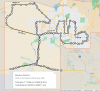
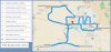
I’ve created a GM route example that duplicates your pictured 1-lap route. Your picture shows 100+ manually entered measurement points, which yields an approximate distance. My route includes 7 waypoints, plus start & finish, with 3 shaping points; this would be as accurate as GM can achieve.
Since the route is a loop, your start & finish could be anywhere convenient along the route. My example route starts & ends near yours, at I-10 & Jackrabbit Trail (nearby 24hr Chevron, Circle K).
GM link:
https://goo.gl/maps/2112frdrmsFAqtGp8
For this 1-lap route, GM estimates a 535 mile distance and a duration of 8 hr 18 min, an average speed of 64.5 mph, which is above the minimum pace for a SaddleSore 1000. Those estimates are based on favorable conditions of traffic & weather, with travel at the speed limits, and do not include the necessary stops for fuel, food, and other breaks.
Regards … Dave