Planning my first IB (Saddle Sore), route suggestions?

sardonicus87

Active Member
I am considering attempting my first IB challenge next year. Going for the basic Saddle Sore. It's not out of nowhere, I take at least one distance trip every year. The furthest I've ever ridden in one go is 850 miles in about 16 hours (headed home from New Jersey), and I did that with no windshield and just a half-helmet (I'm working on a windshield now, I have one, trying to fix helmet buffeting issues with it, I also have upgraded the transmission on my 97 Harley FXSTC to a Baker DD6 that's a lot smoother at highway speed than the stock 5 spd trans I was using before). So, I am not new to riding long distances with the bike I have.

I'm on two other forums, one Harley specific, and they do a meet up that I have done 3 years in a row. I figured this next one, I might try to plan a route to IB it there.

I live in Dothan, AL. The meetup this summer is the same location as last year: Eureka Springs, AK. The route I took last year (best suggested route by Google maps: US-231N to I-85N to I-65 through Memphis into AK, highway 63/65/whatever it is across the entire northern border of AK) is ≈720 miles. I65, greater Birmingham AL area, Memphis bypass all really kind of suck (crappy roads, traffic, etc; another motivation for a different route). I did ride the 720 miles straight through last year (took 13 hours), and combined with some other changes to my ride and based on my experiences so far, I am fairly certain I can have success on my first attempt.

So I did a quick little change with some waypoints. Route looks 1,005 miles (would prefer it being 1,020 miles as a buffer), and estimated 15h 45m according to Maps (would prefer an estimated time closer to 14h than 16 for better leeway, especially considering the average time to complete the 1,000 miles is around 18-18.5 hours). Route is to head south into Florida, grab I-10 all the way to Baton Rouge LA, then eventually to I-49 to Shreveport LA, then up along the eastern border of OK and up western edge of AK to Eureka Springs. A guy I know has offered me to set my end point and spend the night at his house in SE Kansas (would add some more mileage leeway for sure).

That's just the basic route with no other planning—a rough sketch if you will—I'll attach a screenshot of the map.

Has anyone ridden through these areas? How are the roads? I know going through Mobile AL on I-10 has the potential to be a slog, seems there's always a slow down due to a wreck or someone being afraid of the bridge/tunnel (been through there many times). I need to look at alternate routes through there (I know of one, but can't remember the highway name off hand).

But what about the bypass around Baton Rouge, LA or I-49 in LA? Anyone ridden through these areas that has any insight on road conditions and traffic (in general, I know different times will have different traffic conditions)?

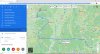
The basic overall map, rough sketch:
Screenshot_20201128-162953.png

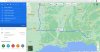
The route last year, Google Maps timeline data, so you know I am not fibbing about distance/time (side note, the time listed, is that strictly travel time, because I stopped where the brown square is for 1.5 hours to rest, I don't know if Google is counting the stopped time in the overall time, or just counting only actual travel time minus stopping?):
Screenshot_20201130-154015.png
 
Last edited:
Sardonicus: Welcome! Awesome on your planning an LD ride. I live in Memphis, have folks in coastal TX, LA, MS, FL, and central FL and in Joplin MO so ran those routes for years on my Ultra Limited. Hats off to you fighting the wind on your FXSTC. Ironically I rode a SS1000 last month from Dothan to Memphis... the long way of course via Texarkana. In most cases, the roads you have chosen are good roads... but timing is everything. When I plan my rides like many... , parts of the planning are ... fuel stops, the weather, the day of the week, and the timing when rolling through "rush-hour" areas. Like many, no problem running across Mobile Bay and through the tunnel, but at times there are back-ups. Red-Stick (Baton Rouge) based on my experiences and the many times through there, clogs up easily crossing the Mississippi. You may want to consider Montgomery to Bossier City to Little Rock to Alma and into Eureka Springs.

Best to you and hope this helps,

Doug Vance
Cordova TN

https://www.google.com/maps/dir/Dot...3e4a53db56!2m2!1d-93.7379711!2d36.4011825!3e0
 

Attachments

  • Dothan to Eureka Springs 1022 mi.JPG
    Dothan to Eureka Springs 1022 mi.JPG
    400.6 KB · Views: 3
Greetings from Wetumpka, AL. I used I-10 as part of a SS 1000 while back. Construction in Baton Rouge was a real issue of stop and go crawling. So check out road work for sure. You may be thinking of US 90 to miss the I-10 tunnel in Mobile. Last time through there I hit it at about 2:30 am so the traffic was understandably light.

I'd use Interstates for my first run, especially at night. I THINK it helps with deer.

You might consider US 231 down to I-10, over to Lafayette, LA then North on I-49 well past Little Rock then due north on a state highway to your destination.

It's right at 1,000 miles so you want to carefully document your corners (Spotwalla is your friend) and even take one of the legs past the planned corners and make a short out and back U-turn of 20-30 additional miles.

Good luck. Ride safe. And let us know how you did.
 
Last edited:
The construction around Baton Rouge can be a royal pain. Avoid rush hour! Nobody there looks for motorcycles and there are plenty of people in a hurry. In fact, I-10 between Baton Rouge and Lafayette is a pretty bad road in general. Last time I was there, they were improving it, meaning plenty of construction. I-49 isn't bad. Not much to worry about there. Louisiana isn't a pretty state to drive through IMO. Very flat. Some people like it though.

Once you make it into Arkansas, it gets hilly and much prettier. Eureka Springs has some great roads around it.
 
At a calculated 1,005 miles, the route is cutting it too close. You should plan a route that is at least 2-3% beyond the calculated 1,000-mile point to be on the safe side.

Ira Agins
Iron Butt Association
 
Not going to quote all the replies, appreciate the responses from everyone.

Well, the guy I know that suggested his place for an endpoint (Coffeeville, KS) is 1,060 miles. I haven't really looked at other potential routes yet.

Obviously, headed toward a major city, I would take a bypass around rather than straight through, but those can be just as bad (sometimes the bypass around Atlanta is worse than just cutting straight through the middle on I75/85, assuming nobody wrecked at "Grady Curve"). I always try to plan ahead for cities like that to hit them off-peak hours, and I usually will pull off just before getting to them to get gas, that way I don't have to try to stop in them.

So it sounds like I'm going to want to avoid Baton Rouge entirely. And Lafayette is where the tentative route picked up I49-N. I kind of figured those areas would be bad. But if there's still lots of construction there, I want to avoid that too, especially at night. That narrow 80 wide front tire catches groves in the pavement in a way that'll make you have to change your underwear.

I haven't considered running due north then cutting west. I forget which interstate runs through Tennessee east/west (I24 I think?), been through that before in a car, wouldn't want to head that way. It was 12 years ago I went through there, but every car with a Tennessee plate was flying at 90 mph through those mountain curves on those steep grade. I'd also prefer to avoid mountain curves on steep grades on the way. The curves around Eureka Springs aren't bad and on that highway in from across the top of the state, even though it's hilly, the grades aren't too bad. By far, my least experience riding is curvy mountain grades (anything over a 5% grade I want to avoid). I've done it before coming through Virgina/West Virgina, and that was no fun, but that was partly all the potholes in the slab that you can't see around the corners.

Yeah, I'm familiar with Eureka Springs, went there earlier this year. Excited to go back June 2021.

I'll take a look at that route of "Montgomery to Bossier City to Little Rock to Alma and into Eureka Springs". As long as I don't have to touch I65 or go anywhere near Birmingham, might be an option. I do want to have at least two different possible routes planned for getting out there, just in case things change between now and June.

EDIT:
Just looked at the route for here to Montgomery, Bossier City, etc. Doesn't look too bad, I see it cuts west on I20 from I85 in Montgomery headed across middle of Mississippi and the top of Louisiana. Miles are better at 1,030. Sounds like a better alternative than taking I-10 over along the coast. Thanks for the suggestion on that. Definitely one route option I will save.
 
Last edited:
So I was looking and I kind of like the looks of this route, just from here to Meridian MS to Shreveport then up to Hot Springs then Coffeeville. 1,060 miles, estimated 17 hours, though I think that's largely due to the first bit of it being US231 to US80 all the way to Meridian before being able to get on the slab. Though, quite similar to the Montgomery/Bossier/LR/Alma/ES route. But I like the other one being an estimated time by Google Maps as 16 h as opposed to almost 18.

That's if I take the guy up on it in Coffeeville.
Screenshot_20201201-035920.png
 
https://www.google.com/maps/dir/Dot...3870b2cc70!2m2!1d-95.6163665!2d37.0373005!3e0

This route has fewer direction changes, closer to your 16hrs, takes you through Eastern Oklahoma which is nice rolling hills and turnpike a good portion of it (toll road).

Ah, when I search on Google Maps, I have the option on to avoid toll roads, that might be why you guys are finding some things slightly different.

But that looks like a much better and more tenable route for going from here to Coffeeville. Going to save that one too.

But yeah, I know 1,030 miles is about 15 hours at an average speed of 70 mph, which in reality translates to 16 hours on a Google Maps estimate, if you get almost all slab with a speed limit set at 70 mph. That's why I was looking for an estimated time closer to 16 hours, because I know the average speed will not be 70 mph factoring in rests and breaks and gas stops, etc, the average speed will be more like 55 mph.

So, the longer Google's estimate is, the less 70 mph slab it has on the route.

1,030 miles in 18 to 18.5 hours makes an average speed of 55-57 mph. But if you got 200 miles of highway where the speed limit is 50-55 mph, that's going to tank that average speed. But just doing rough calculations, average speed of 55-60 mph seems relatively safe and well paced. It also seems in line with my average speed for longer trips (whenever I've done 700-800 miles in a day).

The other thing, if Google says it's 16 hours and for a biker that translates to more like 18 hours... that's a 12.5% increase in actual time vs Maps estimated time. So if the maps estimated time is 18 hours, that translates (at the same rate) to 20.5 hours. That's why I am looking for routes that are closer to 16 hours rather than 18 (by Google's estimated time).

Getting the time right and getting out the minute I wake up (having packed and prepped the night before) is crucial to anyone trying distance riding, but for me, it's even more crucial as I have a circadian rhythm disorder (I sleep from about 4 am to noon most of the time, DSPD). So, I can't leave at midnight to arive in the afternoon. Everything gets shifted way over and because of the DSPD, I can't just "go to sleep early" (melatonin supplements, sleep aids, nothing works) or "wake up earlier" (which, "early" means 9 or 10 in the morning). Though it does give me one advantage: my natural peak alertness is in the middle/late afternoon, right when rush-hour starts.
 
Please be safe on whatever route you choose, know your limits and abide by them. Great tips in the Archive of Wisdom link posted by DrNeo.
 
I *really* wouldn't try to out-guess the Google estimate for time.

Recall, it's only valid at the time you make the route - like at that moment in time. It's constantly taking current traffic issues on your route into consideration. Beyond that, it's a good-enough SWAG for most to go with it.

I have done a sub-16hr Saddlesore, but that was the *second* SS1000 I did, not the first. I simply wanted to know what a BBG pace was. 100% of that route had speeds of 65MPH and higher, so it was easy to keep the overall speed good.

What keeps you from loss of (major) time? For me, it's making sure those first three fuels stops are as efficient as you can make them.

Luck to ya!
 
Thanks guys. I think the route I'm settled on through Meridian, MS to Shreveport, LA to Lindale, TX to either Grove, OK or Coffeyville, KS is pretty good. It's 1,030 minimum miles, no zig-zagging (less corners to have to get receipts from), no major metro areas or construction (at least none reported to Google Maps).

Now I'm excited, I almost can't wait until June.
 
Back
Top