Ride Around West Virginia

AirbusFlieger

Well-Known Member
#1
Let me start with this: I'm a Mac user. Evidently, the trip planning app community thinks no one with an Apple product ever goes on a more complicated road trip than point to point, with two points. MAYBE a stopover, but that's really pushing it. After this route planning exercise.. which has resulted in aborting the RAWV ride I should have left already on as I write this.... I think I may buy a Windows laptop. Garmin Basecamp downloads onto the Mac, but then it won't recognize my Zumo, and when I attempt to buy a map just so I could have it on my computer, it won't let me buy a map so my Basecamp has no maps.

The planning for this one is... a challenge.

After manually routing GoogleMaps, and Harley-Davidson trip planner, as well as my handheld Garmin Zumo XT, I cannot get the algorithms to stay in West by gosh Virginia because of rivers and ridges.

I added 25 waypoints in GoogleMaps and it cannot scroll down the page any more, which means if I use my trick of adding a + and a / right after the @ symbol in the url window, it won't let me click onto what it finds, so that new waypoint will not load. The page cannot be scrolled. In other words, it hit a hard limit.

I spent literally hours of playing around with GoogleMaps, on Safari and Firefox, I have given up, and have resorted to zooming in closely on GoogleMaps using it like a paper map, and writing my own route in print.

GoogleMaps is the official "lets see if the planned route meets the mileage" standard by IBA.

-however-

I cannot for the life of me get a "Round Robin" route all nice and pretty with a total mileage like I was able to on the Ride Around Virginia. The route is just too complicated with many mountain passes, rivers, lack of interstates, and an absolutely schizophrenic state border.

Question for the IBA is:

-Submit a 'Round Robin' GoogleMap I was able to create, with two areas of leaving the state but makes a pretty outline of WV and the mileage is very close because the deviations are at rivers with the roads on both sides following closely the river,

or

-Break up the GoogleMap planning into the DBR city pairs were I can manually manipulate each leg, and submit the GoogleMap plans leg by leg. The reviewer will have to add each legs miles together for the total. I will do this for them as well?

To be clear: I WILL BE RIDING 100% IN WEST VIRGINIA. If I submit a "round robin" it will not reflect precisely what I ride. If I submit city pairs of DBR cities the GoogleMap planning will be accurate to what I plan to actually ride barring safety concerns or other issues forcing a route change.

I will of course be using Spotwalla with my Zumo XT, SW Tracker on the iPhone, and the Garmin Zumo XT's internal tracking/breadcrumbing feature than can be shared to show the route ridden

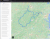
Here is a screen shot of the "round robin", which looks good, but the routing is incomplete as it hit a hard limit on waypoints

. RAWV GoogleMap round robin.png
 
Last edited:

AirbusFlieger

Well-Known Member
#2
Responding to my own post....

The plan is to submit a "leg by leg" format.

I've been playing with the "leg by leg" format and it is quick and easy.

It's possible I launch out tomorrow and begin the RAWV with full knowledge that the attempt could, and likely will, turn out to be a scouting mission/trial run.

I took Monday and Tuesday this week off, giving three days to to the RAWV (including today, Sunday, which of course was spend goofing with maps).

Work needs me Wednesday no later than noon....
 

Avi Azrieli

Premier Member
#3
I’m just responding to your issue with the Mac. Maybe you already know all this, but just in case:
I use Basecamp on a Mac. To get the maps, you need to install Garmin Express on your Mac and connect your Zumo (or any Garmin GPS unit) to your Mac. Garmin Express allows you to get updates and download maps to your device. Then, it gives you the option to also download the maps to your computer—and that’s how you get the matching maps on your Basecamp.
As to why your Basecamp doesn’t recognize your Zumo: make sure your unit battery is fully charged. Then, like everything else with Basecamp, be patient. It may take 10 minutes or more for Basecamp to recognize your unit, at least the first time.
Enjoy WV — beautiful twisty roads everywhere!
 

AirbusFlieger

Well-Known Member
#4
I’m just responding to your issue with the Mac. Maybe you already know all this, but just in case:
I use Basecamp on a Mac. To get the maps, you need to install Garmin Express on your Mac and connect your Zumo (or any Garmin GPS unit) to your Mac. Garmin Express allows you to get updates and download maps to your device. Then, it gives you the option to also download the maps to your computer—and that’s how you get the matching maps on your Basecamp.
As to why your Basecamp doesn’t recognize your Zumo: make sure your unit battery is fully charged. Then, like everything else with Basecamp, be patient. It may take 10 minutes or more for Basecamp to recognize your unit, at least the first time.
Enjoy WV — beautiful twisty roads everywhere!
Thank you.

What I did was load each city pair as separate Trips on the Zumo and saved them into 15 Trips.

Learning this technical stuff is a real challenge for me... I've only used a GPS once for a multi-stop trip, Ride Around Virginia.

Foolishly I left the route planning to last and it burned up a day and a half of my off time and now there is not enough time to do the RAWV.

There is time for me to do a SS1000 or BB1500, so maybe I'll just do an easy 1500 mile interstate loop... or do part of the RAWV as a scouting expedition.

This is all so new to me, that I cannot fathom doing any kind of rally at this point...

"So, AB, how was your rally?"

"I almost had it planned and loaded into the GPS when the riders returned at the end...":oops::rolleyes:;)
 

Mike Nash

#77672
Premier Member
#5
Airbus,

I think you will find that using your trick "I added 25 waypoints in GoogleMaps and it cannot scroll down the page any more, which means if I use my trick of adding a + and a / right after the @ symbol in the url window, it won't let me click onto what it finds, so that new waypoint will not load. The page cannot be scrolled. In other words, it hit a hard limit." and adding your 15 legs together in notpad as an url and then pasting the giant url into the browser it should work. It works best if you use the coordinates rather than the name because if there are two places with the same name it wil pick the first one it comes to.

Example
Leg 1
https://www.google.com/maps/dir/Emp...ruck+Parking+Westbound,+Middlebury,+IN+46540/

Leg 2
https://www.google.com/maps/dir/Ind...+Westbound+-+Tiffin/Rest+Stop+I-80+EB+Ladora/

Combined legs
https://www.google.com/maps/dir/Emp...+Westbound+-+Tiffin/Rest+Stop+I-80+EB+Ladora/

Here is a link where I learned how to do this.
https://winbuzzer.com/2021/02/12/ho...e-than-10-destinations-on-google-maps-xcxwbt/
 

IndianRider

Premier Member
#6
Thank you.

What I did was load each city pair as separate Trips on the Zumo and saved them into 15 Trips.

Learning this technical stuff is a real challenge for me... I've only used a GPS once for a multi-stop trip, Ride Around Virginia.

Foolishly I left the route planning to last and it burned up a day and a half of my off time and now there is not enough time to do the RAWV.

There is time for me to do a SS1000 or BB1500, so maybe I'll just do an easy 1500 mile interstate loop... or do part of the RAWV as a scouting expedition.

This is all so new to me, that I cannot fathom doing any kind of rally at this point...

"So, AB, how was your rally?"

"I almost had it planned and loaded into the GPS when the riders returned at the end...":oops::rolleyes:;)
Maybe dispatch can uplink it for you! ;)
 

JAVGuzzi

Premier Member
#7
Airbus:

Personally, I don't like doing "routes". I use the Garmin POI Loader to enter all the stops into my Garmin - they will be in the Garmin "Extra's" folder. You could enter them manually using coordinates, too. Then during my ride, I just load my next stop as my next "Destination" . I keep a list of all the destinations in cronilogical order in the top of my tank bag along with the estimated depart time for each to see if I'm on schedule.

Just my 2-cents.
 

Russ Black

Premier Member
#8
Once you have the locations in the GPS by what ever method you prefer, you can use the GPS's built in Trip Planner to string together all the points into a route. You can set a departure date/time and layovers for each stop. Basecamp with out Basecamp.

I still have and occasionally use an ancient Nuvi 40 that I mostly use as a backup to the backup that can only do point to point with a single via in between. I number the points in the order I need to visit them by putting a "01-" in front of the first point and "02-" in front of the second point and so on. That way I don't need an additional peice of paper to keep track of and it requires less brain power when fatigued. From the starting point I enter the second point (02-) as my destination and the first point (01-) as the via. The GPS then creates a three point route from my location to the next point (01-... the via) and on to the point after that (02-). Then I do it again with the next two points. Two point ahead for the destination and one point ahead (the next stop) for the via. I did it that way because there were times that I could not enter the next location for various reasons (Safety, Traffic, Weather) and it also showed me which way I had to go after the stop because the GPS more often than not, loses it's bearings at stops and after entering the next point you think it is telling you to exit the station where you entered it and go right when it is actually telling you to exit on the other side of the station and turn right.

I too use a Mac. Avi Azriell has given you the skinny on how to get the new maps on both your GPS and into Basecamp. Actually Basecamp can use the map on your GPS as long as it is connected and recognized in Basecamp (Which sometimes seems forever). You just have to select it using the MAPS tab. The maps are rather large. Several GB's. My riding/rally partner uses the Windows version and I the Mac. They are not mirrors of each other but do the same thing. Here is the link to the "Owners Manual" for the MAC version.

There are advantages to breaking up your route into legs. For one is the amount of time that the GPS takes to process it. I have older GPS's and it takes them some time to process the transferred route from Basecamp. Sometime so long I think it is frozen. It all depends on how complex the route is. Another is that you might change something in the next leg or eliminate it all together.
 
Last edited: